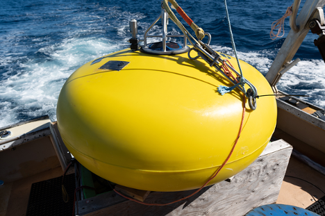
The subsurface buoy is about 800 pounds and will reside approximately 100 meters beneath the ocean surface. The instrument in the middle of the donut is a 300 kHz ADCP that measures the ocean current velocities above the buoy.
This month Dr. Mike Muglia and his team deployed a sub-surface buoy just east of Cape Hatteras on the upper shelf slope under the edge of the Gulf Stream in water 230 meters deep. The deployment site is the focus of the North Carolina Renewable Ocean Energy Program’s (NCROEP) Gulf Stream energy resource characterization. This effort is just one of many which will move NCROEP towards their goal of harnessing the power of Gulf Stream currents as a renewable energy source for the state of North Carolina.
Excitingly, the recent deployment was full of inter-agency collaboration. It was the second deployment done in collaboration with Bob Heitsenrether’s Ocean System Test and Evaluation Program (OSTEP) team at NOAA, who are interested in developing a buoy to measure currents in a deep-water, high-current environment. Additionally, Jennifer Dorton at SECOORA connected Dr. Joy Young who works for the FACT (Florida Atlantic Coastal Telemetry) Network with Muglia’s group, suggesting the group had offshore moorings she might like to take advantage of for attaching a FACT acoustic receiver. The Ocean Energy Site off of Cape Hatteras was appealing because FACT did not have many deep-water test sites, and as Muglia puts it, “It’s an interesting place because Cape Hatteras is the ‘Mason Dixon Line’ for shelf oceanography to the north and south on the east coast.”

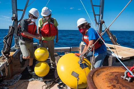
Nick DeSimmone, Bob Heitsenrether (NOAA), and Trip Taylor prepare a smaller set of subsurface buoys that will hold acoustic releases off the bottom just above the train wheel anchor. The releases are used for recovering the buoy after the 1- year deployment.
About the buoy and deployment, Muglia explains, “We are interested in having the near-surface current measurements in the GS, as well as measurements of the salinity, temperature, and depth that will come from two devices known as CTDs. One CTD is located about 100 meters below the surface and the other is 165 meters below the surface. They will help us characterize the different water masses present at the mooring site.” The team suspects to find waters from the Slope Sea, the Gulf Stream, and shelf water from the Mid-Atlantic Bight and South Atlantic Bight from the north and south respectively.
The buoy system will remain at the site and collect information for approximately one year. In addition, Muglia’s group has a collocated bottom pod with a 150 kHz Acoustic Doppler Current Profiler (ACDP) which can take nearly full water column measurements, a passive acoustic hydrophone to listen for marine mammal presence for Dr. Lindsay Dubbs, and another CTD. The NOAA buoy complements measurements from the bottom pod by providing higher-resolution (1 meter) current measurements closer to the ocean surface and water temperatures and salinity throughout the water column. Hopefully, data collection will go as smoothly as the deployment and there will be plenty of new information to process going forward. Muglia expresses great thanks to all who made the deployment happen.