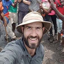
David Lagomasino

Assistant Professor
Department of Coastal Studies
Growing up in South Florida, Dr. David Lagomasino had Miami Beach and the Everglades at his backdoor. His fascination with the beach and mangrove forests have taken him around the world which led him to another spectacular coastline, the Outer Banks of North Carolina. Lagomasino first came to North Carolina in 2007 to complete a M.S. in Geology at East Carolina University. There he was charmed by the extensive marshes surrounding Pamlico Sound and the 200-mile stretch of sandy beaches during his thesis studies. After ECU, he returned to South Florida for a Ph.D. in Geological Sciences at Florida International University. At FIU, David used satellite imagery and water chemistry to identify “hidden” pathways of water flowing in the coast both underground and through the trees. Before coming back to ECU and the Department of Coastal Studies, Lagomasino was conducting research at NASA’s Goddard Space Flight Center just outside Washington, D.C., in partnership with the University of Maryland. While at NASA, Lagomasino used his expertise in remote sensing and coastal processes to develop models that measure the where when, and why shorelines are the world are changing.
Lagomasino uses satellite, airborne, drone, and ground measurements to identify areas of coastal resilience and vulnerability. His research links remotely sensed spatial data directly with stakeholders in order to address exposure and sensitivity issues for coastal/wetland management and ecosystem valuation. He has been involved in a number of coastal blue carbon projects with funding from NASA’s Carbon Monitoring Systems Program, NASA’s Biodiversity and Forecasting Program, USDA’s National Forest Inventory Assessment Program, NASA’s New Investigator Program, and the Center for International Forestry. Through his projects, Lagomasino has visited coastal regions around the world and gained insights into coastal issues many other countries face that are similar to North Carolina and the US. Throughout his research and field campaigns, Lagomasino works to engage students in every step of the research process, from sample collection and data analysis to oral and written presentation. His goal is to provide meaningful information that will better inform coastal management practices while also inspiring students and the community to become environmental stewards in order to help sustain our coastal resources.
Education
Florida International University, Ph.D., Geological Sciences, 2014
East Carolina University, M.S., Geology, 2009
Florida International University, B.S., Geological Sciences, 2007
Professional Experience
2019 to Present: Assistant Professor, East Carolina University – Department of Coastal Studies
2017 to 2019: Assistant Research Professor, University of Maryland – Department of Geographical Sciences
2014 to 2017: Scientist I, Universities Space Research Association
Selected Publications
Lagomasino, D., Fatoyinbo, T., Lee, S., Feliciano, E., Trettin, C., Shapiro, A. and Mangora, M.M., 2019. Measuring mangrove carbon loss and gain in deltas. Environmental Research Letters.
Zhang, C., Durgan, S.D. and Lagomasino, D., 2019. Modeling risk of mangroves to tropical cyclones: A case study of Hurricane Irma. Estuarine, Coastal and Shelf Science
Rahman, M., Lagomasino, D., Lee, S.K., Fatoyinbo, T., Ahmed, I., and Kanzaki, M. 2019. Improved assessment of mangrove assessment in Sundarbans East Wildlife Sanctuary using WorldView 2 and TanDEM-X high resolution imagery. Remote Sensing of Ecology and Conservation.
Fatoyinbo, T., Feliciano, E., Lagomasino, D., Lee, S.K. & Trettin, C. 2017. Estimating mangrove aboveground biomass from airborne LiDAR data: a case study from the Zambezi River delta. Environmental Research Letters
Lee, S.K., Fatoyinbo, T., Lagomasino, D., Osmanoglu, B. and Feliciano, E., 2016. Ground-level digital terrain model (DTM) construction from TanDEM-X InSAR data and WorldView stereo-photogrammetric images. In Geoscience and Remote Sensing Symposium (IGARSS), 2016 IEEE International.
Lagomasino, D., Lee, S.K., Fatoyinbo, T., Feliciano, E., Trettin, C., & Simard, Marc. 2016. A comparison of mangrove canopy height using multiple independent measurements from land, air, and space. Remote Sensing.
Lagomasino, D., Fatoyinbo, T., & Lee, S.K. 2015. High-resolution forest canopy height estimation in an Africa blue carbon ecosystem. Remote Sensing in Ecology and Conservation.
Lee, S.K., Fatoyinbo, T., Lagomasino, D., Osmanoglu, B., Simard, M., Trettin, C., Rahman, M., & Ahmed, I. 2015. Large-scale mangrove canopy height map generation from TanDEM-X data by means of Pol-InSAR techniques. Geoscience and Remote Sensing Symposium (IGARSS), 2015 IEEE International.
Gaiser, E.E., Anderson, E. P., Cataneda-Moya, E., Colload-Vides, L., Fourqurean, J.W., Heithaus, M.R., Jaffe, R., Lagomasino, D., Oehm, H.J., Price, R.M., Rovera-Monroy, V.H., Roy Chowdhury, R., & Troxler, T.G. 2015. New perspectives on an iconic landscape from comparative international long-term ecological research. Ecosphere.
Troxler, T., Barr, J., Fuentes, J., Engel, V., Anderson, A., Sanchez, C., Lagomasino, D., Price, R.M., & Davis, S. 2015. Component-specific dynamics of mangrove CO2 efflux in the Florida coastal Everglades. Agricultural and Forest Meteorology.
Lagomasino, D., Price, R., Whitman, D., Campbell, P., Melesse, A., & Oberbauer, S. 2014. Spatial and temporal variability in spectral-based evapotranspiration measured from Landsat 5TM across two mangrove ecotones. Agricultural and Forest Meteorology.
Lagomasino, D., Price, R., Hererra-Silveira, J., Wilhelm-Miralles, F., Merediz-Alonso, G., & Gomez-Hernandez, Y. 2014. Connecting groundwater and surface water sources in a groundwater dependent coastal wetland: Sian Ka’an Biosphere Reserve, Quintana Roo, Mexico. Estuaries and Coasts.
Lagomasino, D., Price, R., Whitman, D., Campbell, P., & Melesse, A. 2014. Estimating estuarine hydrogeochemistry using leaf and satellite reflectance in two coastal mangrove communities. Remote Sensing of Environment.
Lagomasino, D., Corbett, D.R., & Walsh, J.P. 2013. Influence of wind-driven inundation and coastal geomorphology on sedimentation in two microtidal marshes, Pamlico River Estuary, NC. Estuaries and Coasts.